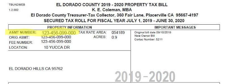
An APN, or assessor's parcel number, is the unique identifier a county assigns to every parcel of land inside its boundaries. APNs are extremely essential to local land management, as they are the unique identifiers used by the county to track who owns a property, what it is worth, what it owes, and what has been recorded against it.
APNs are different from addresses largely because they are meant to perform different functions. Addresses are for mail delivery—they get reassigned, they repeat across cities, and vacant land often has none at all. This is an issue when you want to have a constant reference for a parcel—you want to make sure that a county deed recognizing your ownership of a parcel...is referring to the correct parcel. That is where APN comes in.
To describe what APN is, it is easier to look at what it isn't. APNs are:
- Not a legal description. The legal description is the written boundary language in the deed. The APN is a short administrative code the assessor uses for tax records. One is the definitive boundary; the other is the filing label.
- Not a lot number. A lot is a recorded subdivision unit. A parcel is a taxation unit. They frequently line up, but a single APN can cover several lots, and some lots never get their own parcel.[1]
- Not a national ID. APNs are unique within a county, not across the country. The same string can exist in a dozen states.
You don't need to understand what these three exactly are—we will be exploring each concept further in future articles. But for the purposes of understanding APN just know that these are unique numbers associated with a taxable parcel that is not unique across states. They contain no information about the boundaries of a property—simply that it exists. APNs are more of a record keeping identifier than anything else.
# How to read an APN
While APNs look like randomly generated serial numbers, most APNs do contain some information about the parcel's geography. The classic format is book–page–parcel, which points to a physical location in the assessor's map books.
Sidenote: Tax assessor's have mapbooks of the entire county that showcase the jurisdiction in detail.San Diego County maintains more than 29,000 assessor's maps covering roughly one million parcels.[2]
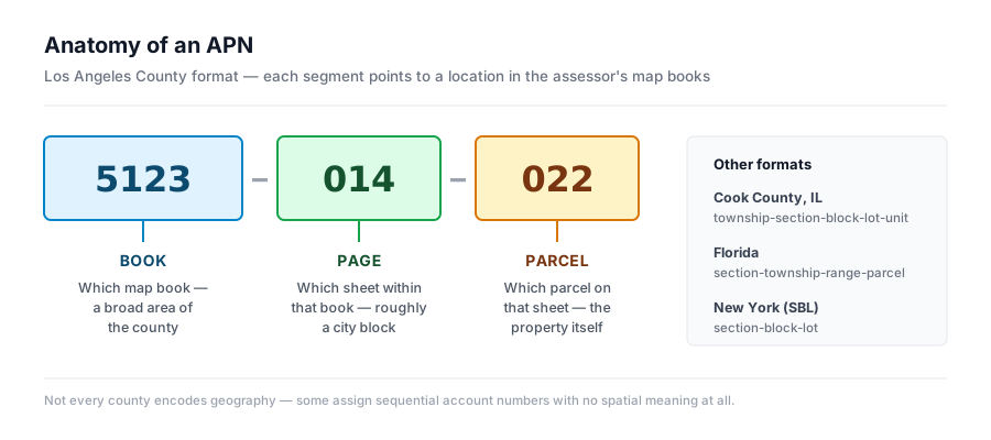 The three segments of a typical California APN and what each one points to.
Learning to read the number means you can pull every parcel on a page just by searching the book and page digits. For instance, in Los Angeles County, a 10-digit number like 5123-014-022 reads as map book 5123, page 014, parcel 022 on that page.[3]
Other states encode different grids. Cook County, Illinois uses a 14-digit PIN built from township, section, block, lot, and unit. Florida counties commonly build the number from section, township, and range.[4] New York uses SBL — section, block, and lot.[5] If you already know how to read a zoning and land use map, the logic will feel familiar.
That isn't to say that everyone does it the same way—Some counties skip the geography entirely and issue sequential account numbers with no spatial meaning. There is no rule requiring otherwise.
# Why does every county do it differently?
Because nobody has the authority to make them do it the same way.
The United States has no national cadastre—no single, authoritative map of who owns what. Property assessment is a local function, so the numbering follows whichever office draws the maps, and that office answers to the county rather than to any federal standard. With more than 3,200 counties and county-equivalents producing parcel data, that produces more than 3,200 numbering conventions.[6]
This decentralized system has continued, despite attempts from the federal government to correct it. A National Research Council report in 1980 laid out the case for a multipurpose national cadastre. A follow-up in 2007 found parcel data still spotty, non-digital in many places, and inconsistent in format across the country.[7]
The issue is that the Bureau of Land Management holds the federal cadastral mandate but has never been given the authority or the funding to execute a comprehensive plan.[8] As of 2007, only about a third of US counties published digital parcel data at all.[9] The Congressional Research Service concluded that the obstacles were less technical than organizational and political.[10] If a new administration choose to make data standardization a national priority, we would see centralized APNs.
Until then, the result is a terminology zoo. Florida calls it a folio number. Illinois calls it a PIN. New Jersey uses block and lot. Hawaii uses a Tax Map Key. Los Angeles County calls it an AIN.
Same concept, different label, different format, different portal. If you want the fuller picture of why American land administration fragments this way, our guide to the types of local government in America covers the structure underneath it. (Spoiler: It has to do with how America was formed in the first place)
# Who assigns APNs and when do they change?
The assessor's office assigns the number, usually through a dedicated mapping division. But the office is not called the same thing everywhere, and in some states the work is split. Texas separates the two functions entirely: 253 central appraisal districts handle valuation and property records, while the county clerk handles recording and a separate tax assessor-collector handles billing.[11] So, local knowledge is essential for handling APNs.
Assignment follows recorded documents. The assessor does not invent boundaries. Rather it redraws its maps to match what was recorded.
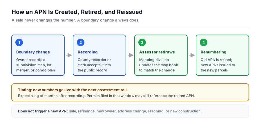 A sale never changes the APN. A boundary change always does.
When a parcel is split, merged, or condo-mapped, the existing APN is retired and new numbers are issued to the resulting parcels.[12] Selling the property does not change it. Neither does refinancing, rezoning, or building on it.
The timing gap matters for anyone tracking development. A subdivision map records on one date, the assessor redraws on another, and the new numbers typically go live with the next assessment roll. During that window, permits and staff reports may still reference a parcel number that no longer exists. Being vigiliant about these potential changes will help avoid a lot of headaches.
# Why the APN matters in real estate
The APN is the join key that connects assessor records, recorded deeds, title commitments, permit files, GIS layers, and planning agendas. All of this data is maintained by different offices in different systems with the parcel number usually being the only field they share.
On a practical note, these parcle numbers are essential for multiple functions. Title and due diligence work is indexed by APN. Permit history is filed against it. Property tax appeals require it. Public notice mailings for a hearing are generated by pulling every parcel within a fixed radius of the subject site, which means the APN determines who legally has to be told your project exists. And if you are assembling a site or tracking a competitor, the APN is how you confirm that four separate listings are actually one contiguous holding.
It also matters for anything happening upstream of a permit. Rezonings, variances, and conditions of approval get discussed in public meetings months before they appear in any property record, and those discussions are almost always anchored to a parcel number. GatherGov monitors meeting records across thousands of jurisdictions, so a parcel you are watching surfaces when it hits an agenda rather than when it hits the assessment roll. For the sequence of approvals that follow, see our walkthrough of the land entitlement process.
# Where APNs break
As you may have gathered by now, the decentralized and fragmented nature of APNs mean that at times, these numbers break. What does breaking mean? They don't function as you want a unique identifier to function. These are just some places where APNs can mess up your data processes.
Retired APNs destroy time series. Because APNs can change after subdivision, they are a pain when you are working with any time series data. For instance if you assemble a portfolio history by parcel number, every subdivision in your dataset looks like a property that vanished. You need the predecessor-successor relationship, and many counties do not publish it cleanly.
Formatting is inconsistent within the same county. The tax bill shows the APN with dashes; the GIS layer stores the number without separators, or with leading zeros the assessor's portal drops.[13] Despite APNs being the only join key, sometimes that join is not reliably clean.
Uniqueness is only county-deep. Always carry state and county FIPS codes alongside the APN. Without them, a multi-state dataset will collide.
One project is rarely one parcel. Large developments span dozens of APNs, condo buildings generate one per unit, and a single parcel can hold multiple structures. APNs are for tax purposes and sometimes will not relate to building footprint.
Not every APN is a property. Streets, alleys, and rights-of-way often carry placeholder parcel numbers assigned to a public agency.[13] They show up in radius searches and skew any parcel-level analysis that does not filter them out.
# Where to find your APN
In rough order of speed:
- Property tax bill — usually printed at the top, labeled APN, PIN, folio, or account number.
- Deed or title report — included in the property description; title companies list it in the preliminary report.
- County assessor's portal — searchable by address or owner name in nearly every county.
- County GIS parcel viewer — click the parcel on the map and the number appears in the popup.
- Statewide or national parcel data — for bulk work. Commercial aggregators now cover essentially every US county, standardizing local formats into one schema.[14]
If none of those turn up a record, call the assessor directly.
For teams tracking more than a handful of sites, going county by county misses many information. GatherGov was built for the layer above the parcel record — the meetings, agendas, and staff reports where a parcel's future gets decided — so you can watch a market and see what is affecting your parcel.
# Frequently asked questions
What does APN stand for? Assessor's parcel number. Some counties write it as assessor parcel number or assessor's identification number (AIN). Same thing.
Is an APN the same as a parcel ID or PIN? Functionally yes. APN, parcel ID, PIN, folio number, tax map number, and tax ID are regional names for the county-assigned identifier of a parcel. Confirm the format your county uses before searching, because the punctuation often differs from what appears on the tax bill.
Does the APN change when a property is sold? No. The APN attaches to the land, not the owner. It changes only when the parcel's boundaries change through a recorded subdivision, merger, or condo map.
Can two properties have the same APN? Not within the same county. Across counties, yes — parcel numbers are only unique inside the jurisdiction that issued them.
Do other countries use APNs? Most use a national equivalent. The Netherlands registers all property through a single national agency, and Australia's state land registries feed a unified national cadastre.[15] The identifier is consistent countrywide because one institution issues it. The US has no equivalent layer above the county, which is why American parcel identification stops at the county line.
How do I find the APN for a property I don't own? Parcel records are public. Search the county assessor's portal or GIS viewer by address — no ownership or login required in the overwhelming majority of counties.
# Footnotes
-
San Diego County Assessor/Recorder/County Clerk, "Property Information," on the definition of an assessor's parcel and its relationship to recorded lots. ↩
-
San Diego County Assessor/Recorder/County Clerk, "Property Information," reporting more than 29,128 assessor's maps covering approximately 1,001,029 parcels. ↩
-
Beycome, "California APN Lookup: Prop 13, Assessed Value & Your County Assessor," 2026, on book–page–parcel formatting across California's 58 counties. ↩
-
TaxFightBack, "Property Tax ID Number (Parcel Number): What It Is and How to Find It," on parcel number formats by state. ↩
-
Erie County, New York, "Tax Parcel Mapping: Visual Representations of Legal Descriptions," on PIN and SBL numbering procedures. ↩
-
Regrid, "History of Parcel Data," on the absence of a standard method for collecting and disseminating parcel data across roughly 3,200 US counties. ↩
-
National Research Council, National Land Parcel Data: A Vision for the Future, National Academies Press, 2007, and Need for a Multipurpose Cadastre, 1980. ↩
-
Texas Natural Resources Information System, "Digital Parcel Data in Texas," 2019, on the Bureau of Land Management's cadastral stewardship role and its lack of authority and resources. ↩
-
Regrid, "History of Parcel Data," citing 2007 research finding only about one-third of US counties published digital parcel data. ↩
-
Congressional Research Service, Issues Regarding a National Land Parcel Database (R40717), on organizational and political barriers outweighing financial and technical ones. ↩
-
Texas House Bill 3491 bill analysis, 80th Legislature, on the 253 central appraisal districts; SearchSystems, "Texas Property Records," on the separation of appraisal, recording, and collection functions. ↩
-
Shovels, "What Is an Assessor Parcel Number, and How to Find It," 2026, on APN retirement and reissuance after subdivision or merger. ↩
-
UrbanKit Studio, "APN (Assessor Parcel Number) Explained," on separator mismatches between tax bills and GIS systems and on right-of-way placeholder parcels. ↩ ↩[2]
-
Regrid Data Store, reporting approximately 160 million parcel records standardized across 3,229 counties. ↩
-
Kadaster (Netherlands Cadastre, Land Registry and Mapping Agency), "About Us"; Geoscape Australia, National Cadastre Product Guide, on aggregating state and territory cadastres into a national layer. ↩